So my thought was I'd drive up one of the worst trailhead roads I've ever seen and save some time on the approach.
High scuff marks
I passed a Jeep that was turning back.
Of course he was a wimp, because there was a Civic at the TH when I got there. But that's just plain nuts. Heck, I have almost 9" of clearance and still I heard a scrape from an embedded boulder on the way up.
The basin below Crestone Peak:
My intent was to follow the Humboldt Peak route and then take a left towards Kit Carson and see how it went.
Crestones from the Humboldt saddle:
West of Humboldt is a harmless-looking ridge that ended up being a morass of narrow crests and shattered rock, which leads to the Crestone/Kit Carson saddle. I underestimated this ridge, which is thin, rugged, and slow going.
I ended up traversing along the north and cliffing out, and having to climb up steep scree and rock to gain the ridge again. There were several sections of narrow (~3 foot) catwalk above steeps. I don't climb so I'm not really used to it, and in a couple of spots I was really feeling the heights.
Here I'm about to descend above a steep scree-filled couloir (out of sight) before cutting back up:
Yep, I ran in those shoes. And I got my complimentary Merrell heel blister even with thick REI hiking socks. WTF. I never get blisters from my running shoes, even after 20-30 miles. Merrells always seem to savage my heels.
Kitty Kat Carson in the middle. Boy, that's a long way:
Bottom line, I saw the writing on the wall and knew I wasn't going to make it in one day and then get back home. Plus I wanted to make it to Amica's before the dinner rush (gotta have your priorities straight). I headed back.
Here's "Point Defeat" or "Point 13,307" or whatever it's called, from below (with several miles left to go to my car):
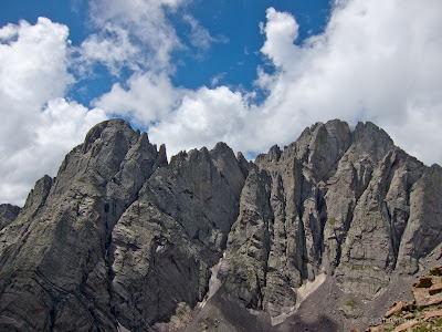
I ended up offering a Texas hiker a lift to save him from that fate; I've been on enough forest roads at the end of a long day to know how that feels. That hiker had set his sights on Crestone Peak, with no equipment and only hiking shoes. Hmm. For the reason why that's not a good idea, see photo #3.
On the way home I passed the turnoff to Cotapaxi because I was unfamiliar with the route options, and as a result had extra mileage to get to Salida on 50 at its crazy-slow speed limit. That canyon is endless when you're expecting a beer and a #16 calzone at Amica's (ridiculously good, as was the server at the bar). Then it was coffee at Bongo Billy's before I dove into a stream of cars heading back to Denver on 285.
One disadvantage of a two-lane highway is the speeding tailgaters -- i.e. unsupervised adult children -- risking head-on collisions. At least the scenery is good.
Distance was 11.43 miles, time 4:58 (moving 3:25), elevation gain/loss 3,643 feet, avg. pace 26:09 (moving 17:58), and best pace 8:17.
That was an interesting outing as an exploration, and as a sort of acclimatization process for more challenging hikes/climbs. But I need more time on rock.


